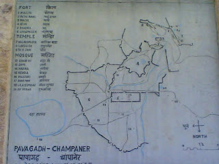
I am not a historian but learning about our glorious past is great experience. Add to this a bit of adventurous exploration and the learning becomes fun. However, please correct me & oblige if you find any facts misplaced or misprinted.
Stone age man is believed to have lived at this site during pre-historic times. Early human settlements were recorded during 6th century AD and Maitrak dynasty is believed to have ruled the area during 7th century AD. Champa or Champaraj, a contemporary of king Vanraj Chavda of Anhilwada, was founder of Champakdurga during 8th century AD. Parmara kings are believed to have ruled the region during 9th century AD and by 11th century AD the region was ruled by Bhimadeva who was later defeated by Muslim rulers. It was during the 13th century AD the Khichi Chauhans, descendants of Prithviraj Chauhan, took over and ruled the region till about end of 14th century AD.
Champaner city was built by Mehmud Begda (1458 – 1511 AD) to conquer the Rajput fort on the hills which the Sultan tried for two years, 1482-84 AD. Champaner city began as a siege camp at the foothills of Pavagadh since direct assault on Jai Singh, son of Patai Raval, to conquer the fort may not have resulted into any success. Islamic influences were thus evident in the region in 15th century AD as Mehmud Begda moved his capital from Ahmedabad to Champaner and changed its name to Muhammadabad.

No comments:
Post a Comment